 |
Distance: 11.3 miles
Ascent: 2100 ft
Walking: Andrew
Weather: Overcast with sunny spells.
OS Map: OL21 - South Pennines
Starting point: Station Road, Oxenhope.
Photography: Andrew using Nikon D750 / Nikon 24-70 mm f2.8 & Nikon 70-300 mm f4.5/5.6
Basically, straight uphill from Oxenhope with a couple of steep bits, to some of the best views in Yorkshire. We can see the cairns at the top from home so it's great to be able to go up there and look back the other way.
 |
| This steep climb from Station Road up to Hebden Bridge Road was definitely the shape of things to come. |
 |
| There seem to be quite a few of these Victorian post boxes round here. this one is at the junction of Hebden Bridge road and Shaw Lane |
 |
| St Mary's Church, Oxenhope |
 |
| These Victorian cast iron way-markers, like the post boxes, are a common sight round here |
 |
| Hard Nese Lane, Oxenhope |
 |
| Shaw Lane and Moorside from the top of an abandoned stone quarry |
 |
| Oxenhope |


 |
| A very pleasant view over Leeshaw Reservoir |
 |
| Another different style of field gate |
 |
| From here you can see the next mile or so of the path I will be following |
 |
| Holden Lane |
 |
| Holden Lane as it crosses Rag Clough Beck |
 |
| Looking back down Kennel Lane |
 |
| Barn at Lowerfold farm |
 |
| Forget-me-nots on Bank Lane |
 |
| Another lovely example of the local art of the make-do-and-mend field gate |
 |
| I was minding my own business listening to (and trying to spot) a cuckoo in a nearby tree when this lapwing started dive-bombing me. I didn't realise until I downloaded the photos that I'd captured another cuckoo flying past when I took this one. |
 |
| Looking back down Bank Lane |
 |
| Leeshaw Reservoir from Bodkin Lane |

 |
| It's a steady climb up Bodkin Lane |

 |
| Those clouds look a bit ominous |
 |
| Looking back down Bodkin Lane |
 |
| Sun Hill Clough |


 |
| Boundary stone on Stairs Lane at a place known as Top of Stairs |

 | |
|

 |
| Having reached the bottom of the valley, it was inevitable that the path would start to climb again up Lane Waste, alongside Grain Water |

 |
| Looking back down Dick Dean Lane |


 |
| Cross Ends Farm across the valley |

 |
| Baby House Hill |
 |
| Baby House Hill ford |

 |
| Approaching the ruined farmhouse at Nook |
 |
| Nook Farm. Although the farmhouse itself is derelict, the attached barns still provide shelter for the sheep on the moor |


 |
| The kitchen fireplace still contains the remains of the range |
 |
| The views down the steep-sided Crimsworth Dean towards Hardcastle Crags are pretty spectacular. You can just about make out Heptonstall church and Stoodley Pike in the distance. |

 |
| I decided to take the slight short-cut straight down the very steep Sunny Bank rather than continue on the top lane then double back down Sunny Bank Road (the walled track), just for the hell of it. |
 |
| I stopped half-way down Sunny Bank to take this and nearly lost my balance |
 |
| One of a couple of derelict farmhouses on Sunny Bank |
 |
| Looking back up Sunny Bank to Nook Farm |
 |
| Sunny Bank road heads down to Crimsworth Dean Beck at Lumb Hole |

 |
| Lumb Hole Waterfall on Crimsworth Dean Beck was lovely and peaceful when I was there early on a Monday morning but judging by how worn the paths are, I'd guess it suffers a similar fate to Goit Stock Waterfall when the weather is good. |
 |
| The waterfall photos were taken with my camera steadied against my walking crook at 100ISO, f22, 1/5 sec. I must get a lightweight tripod |


 |
| Lumb Lane (No, not that one) |


 |
| It started to get dark and looked like it was going to chuck it down as I headed up Gib Lane from Gibraltar Farm |
 |
| Yep! Thought so! |
 |
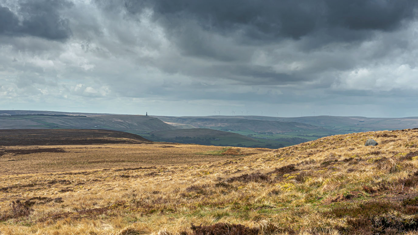
| Stoodley Pike and Heptonstall from Flaight Hill |
 |
| Approaching storms on High Brown Knoll |
 |
| Boundary Stone on High Brown Knoll |
 |
| The view across Midgeley Moor and Warley Moor towards Warley Moor Reservoir and Nab Hill from Limers Gate |
 |
| The path follows this conduit for quite some way across the moor. A network of these conduits was built to connect the many reservoirs up here. This one flows into Warley Moor Reservoir but as I walked alongside it, it appeared to be flowing uphill (which, of course, it wasn't). |


 |
| There's an awful lot of not very much for miles up here but it is beautiful. Note to self - Come again when the heather is in flower |
 |
| Still following the conduit and those wind turbines don't seem to be getting any nearer |


 |
| Warley Moor Reservoir |


 |
| The skyline is completely made up from quarry spoil heaps |

 |
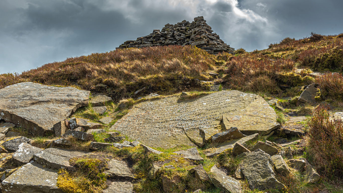
| I took a short detour up to Nab Hill to see the Mist Stanza Stone which i completely missed last Friday |
 |
| Beautiful Bronte Country from Nab Hill |
 |
| The Three Sisters' stone cairns |

 |
| The Mist Stanza Stone sits on the hillside directly below this cairn. I must have more or less stood on it the other day without noticing it |

 |
| The poem inscribed on the stone is by the Poet Laureate, Simon Armitage. There are 5 others in upland locations on a 50 mile walking trail from Marsden to Ilkley. |
 |
| Lovely to see the cotton grass bobbing about in the breeze again |


 |
| Leeming |


 |
| The gathering storm. There was massive clap of thunder just after I took this that made me jump out of my skin |

 |
| Hill House Lane, Oxenhope |
 |
| Lowertown, Oxenhope |


No comments:
Post a Comment