
Distance: 3.5 miles
Walking: Andrew
Weather: Overcast.
OS Map: OL21 - South Pennines
Starting point: Oldfield Primary School
Photography: Andrew using Nikon D750 / Sigma 10 - 20mm f4 - 5.6 / Nikon 70 - 300mm f4.5 - 5.6
Note: I used the 10-20mm to get a wider field of view but using it with the D750 the fall-off at the edges of the image seems much worse than it did with the old D610, regardless of the aperture, so I don't think I'll use it again for general landscape work.
A second visit to Griffe Mill to explore a bit more. The building is clearly unsafe and the landowner has put up plenty of warnings not to enter the ruins so I stuck to the exterior. It's very eerie and fascinating to see how nature is slowly reclaiming it. I must come back here when it next snows.
 |
| The access track down to Oldfield House Farm from Oldfield Lane |
 |
| Primroses |
 |
| I think this is crab apple blossom on what was the access track down to Griffe Mill at the bottom of the valley |
 |
| Stanbury on the opposite side of the valley |
 |
| Blackthorn blossom |
 |
| Both sides of the valley are pretty steep and access was always a problem. This may have been a contributory factor in the decision to close the mill in 1928. |
 |
| The first part of the mill you see is this round structure, which has clearly been abandoned for a very long time judging by the height of the trees in it. This appears to have been a gas holder, installed just a few years before the mill closed in 1928. |
 |
| After crossing a small footbridge over the river, the remains of the mill emerge from the thick vegetation. It's all a bit Indiana Jones, really. |
 |
| Built in the late 18th century as a water powered cotton spinning mill, as with many other mills in the area, production changed over to spinning worsted (a smooth wool yarn) in the early 1800s and steam power was later added to supplement the water power. In 1923, a gas engine was installed, just five years before the mill closed for good. |
 |
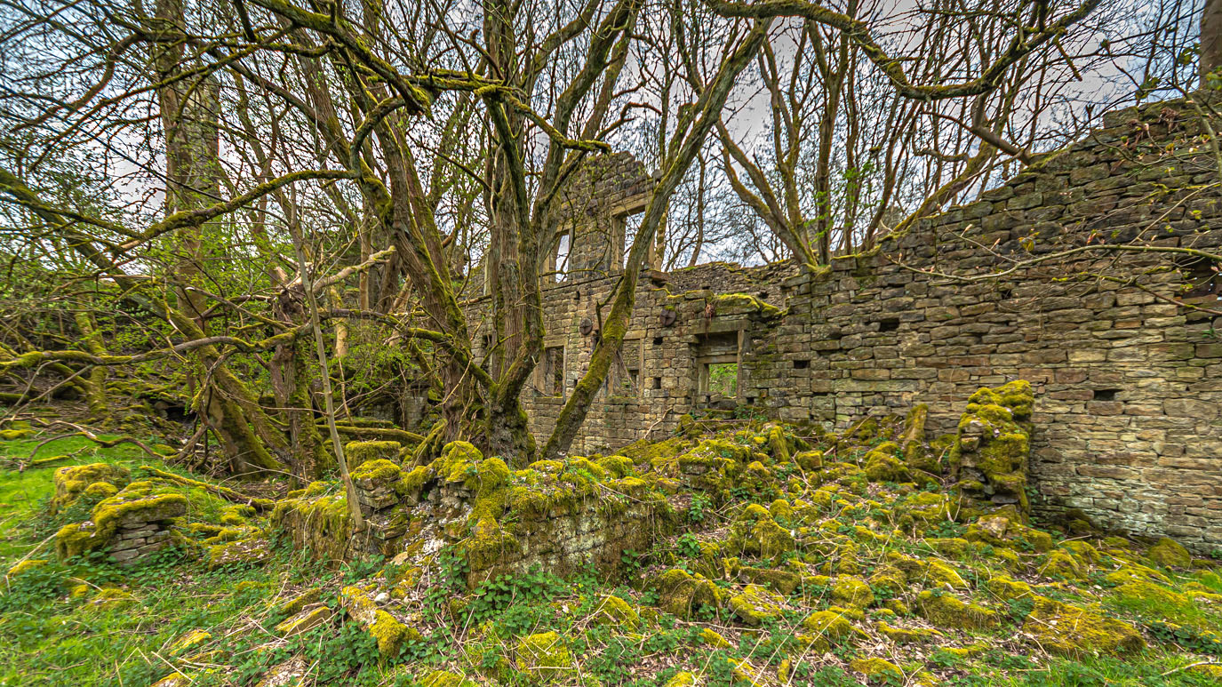
| This is complicated. If you look at any OS map, there is a public footpath to the right of the building which continues up to Stanbury. However, I do have some sympathy with the landowner here. The building has been derelict for the best part of 100 years and, although a fair amount of it remains, a lot of it has collapsed over time and the invasive roots of the trees are bound to make it more unstable. Aside from some makeshift barricades and signs on the doorways, the building has been left to Mother Nature. Fencing the whole site off would be unsightly and very expensive. All I can say is, if you do decide to visit, remember it is private property. Just be sensible, stick to the footpath as best you can and don't take any unnecessary risks. It's not worth it just for a photo. |
 |
| The left hand building was the weaving sheds. You can see where some stonework has been added on top of the original wall but the distinctive asymmetric roofline is still visible |
 |
| The general lack of vandalism and graffiti is a mark of how inaccessible the building is. It can be seen from Stanbury in the winter but is virtually hidden by trees in the summer. I was careful not to get too close (these interiors were taken from outside through doorways and windows). The building is clearly unsafe and I certainly wasn't going to go inside. |
 |
| Maybe I should come here again on a moonlit night. Then again... |
 |
| Back up to Oldfield the way I came |
 |
| The view up the valley. Ponden Clough can be seen to the right near the horizon |
 |
| Back in Oldfield after the steep climb |
 |
| Down the valley towards Haworth |
 |
| Some lovely mossy dry stone walls and an old squeeze style at Dixon Hill Farm, Oldfield |
 |
| Footpath from Manor Farm, Oldfield down to the River Worth |
 |
| Lumb Foot with Haworth beyond |
 |
| Yes, it's that rickety bridge again! |
 |
| Up the valley with The Old Silent Inn in the centre and Master Stones on the horizon |
 |
| The climb up from the bridge is extremely steep and it's not clear exactly where the path goes |
 |
| Having made it up the hill to Stanbury, this is the view back over the valley to Oldfield |
 |
| Honesty and cow parsley in Stanbury |
 |
| Stanbury and Oldfield war memorial is situated in the cemetery between Stanbury and Lumb Foot and commemorates 11 local men killed in the First World War. For more details, go to the Men Of Worth website |
 |
| A typical local field barn |
 |
| Lower & Higher Scholes with High Hob Cote beyond |
 |
| Looking down the valley from above Lumb Foot. Long Bridge can be seen in the centre foreground |
 |
| A wonderful piece of Yorkshire humour at Lumb Foot |
 |
| Lumb Foot packhorse bridge |
 |
| Lumb Beck. Slightly disappointed that the bluebells were not quite out yet. There was the odd one or two dotted about but nothing like last year |
 |
| Approaching Near Scholes Farm |
 |
| Didn't expect to see this in the middle of a field |
 |
| Wood sorrel on Dark Lane |
 |
| Those flippin' dandelions get everywhere |
 |
| Ivy-leafed toadflax is a common sight in the walls round here |


No comments:
Post a Comment